
Citycare Property prides itself on being a progressive, agile company. Part of that is embracing new technologies as they become available. One such example is GIS Mapping.
Most, if not all of us, would be familiar with maps in their traditional form; cartography, or mapmaking, having played a pivotal role in our understanding of the world around us for millennia.
Geographical Information Systems mapping, better known as GIS mapping, uses software to efficiently and effectively convert geographical data into an easily discernible format — a map, says Citycare Property Senior GIS Specialist Steven Mitchell.
“The process is two-fold: using a mix of GPS numerical data that has been personally collected by either myself or my colleague Hayley Nicol (Citycare Property GIS Specialist), accurate to within 2cm, and high-definition imagery supplied by GNSS satellites, we are able to overlay the raw data and imagery to produce highly detailed digital representations of council-owned attributes and facilities.”

Steven says GIS mapping is primarily used within Citycare Property to provide quantities to asset management as part of the company’s service to Christchurch City Council.
“The data collected is useful for council’s parks department, capital works and facilities management helping assist with revalidations around any changes to parks, paths etc. This is a service that Citycare Property provides as ‘above and beyond’ the parks contract.
“Having that information in a geo-spatial system allows council to better maintain spaces based on the individual lifecycles of the assets within those spaces. Citycare Property has a really good relationship with council’s parks department going back 6–10 years and it’s a great feeling to know that we’re providing work that has a significant value to them.”
Between them, Steven and Hayley carry out work all over Canterbury.
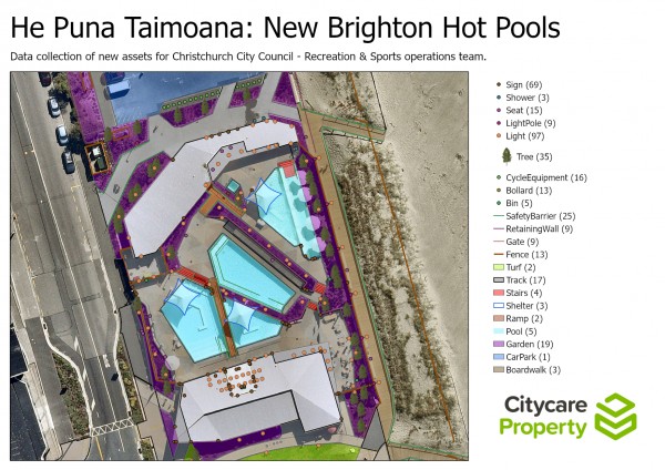
A map produced by the GIS mapping team of He Puna Taimoana: New Brighton Hot Pools for Christchurch City Council showing the position of more than 20 separate elements within the site.
“A lot of what we do is carried out in support of other Citycare Property teams,” says Hayley. “For example, we did data integration alongside the civil works teams involved with multiple playground upgrades and the Waimairi Stream project.”
Hayley says it involves a lot of complex work, which is both physically and mentally demanding and not necessarily finished when the project is.
While the work can be challenging, Steven says they have smoothed out the process a lot over the last couple of years, even to the extent of creating a QR Code-enabled survey that allows other Citycare Property teams to provide updated data.
“GIS mapping is a win-win proposal for Citycare Property. It helps with the tendering process for the parks team and was one of the instrumental reasons they were able to secure the South Wairarapa contract,” says Steven.
“While there’s no denying that that is an important aspect of what we can offer Citycare Property, there are myriad other ways in which GIS mapping can help optimise a lot of our processes.
“It allows us to map the exact shape and size of open spaces, which in turn allows for accurate pricing of jobs, often leading to significant cost savings for clients; we’re able to geo-reference and geo-tag existing pictures, allowing us to create up-to-date records for both Citycare Property and our clients; and, the data transfer software we use works well with excel etc, making this updated information accessible to all areas of Citycare Property.
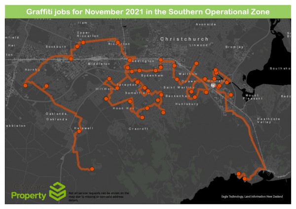
Using GIS mapping, the team was able to create a map of the most efficient route for the Graffiti Team to follow during their site visits, saving them time and the company money.